


Preset
33 Case Studies
A Preset Case Study
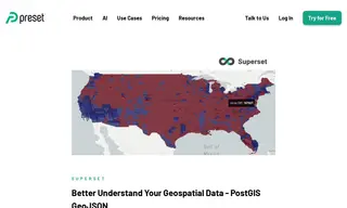
The customer, Apache Superset, needed a more efficient way to interpret complex geospatial data to identify trends and patterns. They partnered with the vendor, Preset, to leverage the capabilities of Apache Superset for advanced data visualization.
Preset implemented a solution using a Postgres database with the PostGIS extension to store and process election and geodata. Using Preset's Apache Superset, they created an interactive 3D map that visualized election results by county, coloring regions by winning party and extruding polygon height to represent total vote count. This geospatial visualization provided a clearer, more intuitive understanding of the data, revealing that while a majority of land area voted Republican, more densely populated Democratic areas held a significant advantage.
33 Case Studies