
Mapbox
217 Case Studies
A Mapbox Case Study
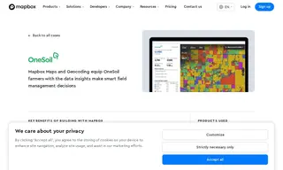
OneSoil helps farmers analyze tens of millions of agricultural fields worldwide but needed a way to effectively visualize this massive amount of data on a map. Their map-driven product required high-quality base maps, rendering, and scalable tileset hosting to provide a critical user experience for their analytics platform.
Mapbox provided their mapping platform, including Base Maps and the Mobile Maps SDK, to equip OneSoil with highly flexible and scalable large-scale data visualizations. By implementing Mapbox, OneSoil enables farmers to see what is growing in their fields and make smarter field management decisions, with Mapbox Search also making it easy to add address search and geocoding features.
217 Case Studies