
12d Solutions
99 Case Studies
A 12d Solutions Case Study
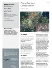
Brisbane City Council engaged 12d Solutions to analyze the surface after the 2011 floods to better understand future impacts. The challenge was that surveyed flood height levels along the river were inconsistent, creating Solutions involved using 12d Model to create a surface that accounted for the super-elevation effect of water on river bends. They supplemented surveyed data with LiDAR and Nearmap imagery to create graded bank strings, which were then tinned to model the flood surface. The result was a highly accurate flood extent map that correlated perfectly with the aerial imagery, providing the council with a valuable tool for future flood planning and understanding.
99 Case Studies